KQ Land Data Processing System integrates data collection, editing, check processing, data storing, database maintenance and alteration. Based on the DOM, the system can achieve data collection. Through the powerful data quality inspection control, it can establish a database of current situation of land use with integration of vectors, images, attributes and documents.
System Functions:
1.Data Collection
Ensuring the topological relation of data in a convenient and rapid way; deciding the capture state according to the shape of the mouse during data collection; simultaneously conducting the operation of point-adding, point-deleting and point-moving towards the coincident data through shared editing; generating graphs by texts and supporting coordinate points input with keyboard and batch import the electronic data of GPS and total station.
2.Data Editing
Offering various graphic editing of points, lines and polygons e.g. division, combination and contiguous development; automatically operating the dividing and combining work in batch; assigning the attributes through single selection or batch and conducting the spatial attribute copy among different layers.
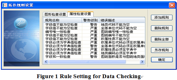
3.Data Check
Customized checking of the error patterns; consistency checking; integrity checking; overlaying and topological checking on single-layered or multi-layered graphs; and provide the error list and locate the incorrect features.
 4.Data Processing
Processing the data in batch or in interactive method according to the detected error types; powerful data topological processing function including basic graph processing, land features normalization processing, path arrangement, ring-on-ring processing, fixed zooming, redundancy disposal and topological consistency processing.
.png) 5.Statistics Analysis
Able to conduct multiple functions such as spatial analysis, buffering zone analysis and random area analysis.
6.Data Transformation
5.Statistics Analysis
Able to conduct multiple functions such as spatial analysis, buffering zone analysis and random area analysis.
6.Data Transformation
Offering multiple formats of data interfaces such as fieldwork measuring documents, SHP, DXF, TXT, VTM; applicable for data coordinates transformation, projection transformation and frame data correction; offering data code conversion, conversion between VCT, SHP and database, conversion between databases and other automatic conversions; providing conversions between ARCGIS and KQGIS., and among all kinds of database.
7.Data Importing
Establishing database structure (National standard database structures are involved by default in this application) base on the users’ needs under the provided database-built dictionary settings; able to input data into database after the establishment of database through the application.
8.Data Maintenance
Offering various kinds of maintenance to the numbers and areas of loaded or stored data.
 9.Data Alteration
Integrating real-time alteration and annual alteration; providing diverse kinds of alteration operations such as alteration fallback, alteration information management and applicable for dynamic balancing.
10.Map Editing and Image Management
Able to conduct symbol library management and production output of thematic map. Including overlay display control of all kinds of image data; graphics correction; null value cutting of image data; pyramid generation and re-construction of pyramid; generating DEM data through images.
 (8610)85271488


 KQ Land Resources Data Processing System
  (8610)85271488
 Service Network
 Join Us
 current position: