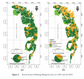
Researchers from Universities Kebangsaan Malaysia (UKM) and Universities Malaysia Terengganu (UMT) combined data from three satellites with previously obtained ground data to investigate changes to the Matang Mangrove Forest between 1993 and 2011.
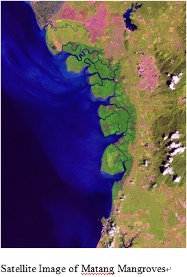
Malaysia's mangroves are the third largest in the Asia-Pacific region. The Matang Mangrove Forest, covering 40,000 hectares of land on the western coast of peninsular Malaysia, is considered one of the best-managed mangrove forests in the world. It became fully protected in 1906.
Mangrove forests grow along sheltered coastlines and form a very unique and productive ecosystem. Unlike other forests, they grow in saline soil and brackish water and are periodically exposed to fresh and saltwater.
The scientists aimed to map using GIS the changes happening in Matang Mangrove Forest to determine what factors might be threatening it.
They found that the forest showed changes to about 8,000 hectares of its area between 1993 and 2011 due to erosion, conversion to dryland forest, agriculture and construction of shrimp ponds. Also, satellite images showed watery areas that were not yet planted with mangroves according to the Matang Mangrove Forest tree harvesting rotation system. This factor contributed to the large amount of changes seen in the forest. On the other hand, the forest also gained almost 3,000 hectares of newly planted mangroves.
This information, the researchers say, will be of added value to Malaysian authorities and other stakeholders in the Matang Mangrove Forest. The findings improve understanding of mangrove distribution and threats and can be helpful for management purposes.
The researchers recommend continuous monitoring using remote sensing data and GIS, since the forest covers an extensive area, making it difficult to monitor and manage. During future monitoring, they recommend using higher spatial resolution imagery to improve the accuracy of recognition of various species and the threats affecting them.
 (8610)85271488


 (8610)85271488
 Service Network
 Join Us
 current position: